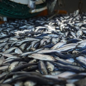
Managed by the Northern Irish Pelagic Sustainability Group (NIPSG), the certificate covers herring caught in the North Sea. NIPSG represents the pelagic members of the Anglo-North Irish Fish Producers Organization (ANIFPO) and the Northern Ireland Fish Producers Organisation (NIFPO).
The fishery targets herring using only three boats – pelagic trawlers - with fishing taking place mainly during the hours of darkness. Their boats: Voyager, Stephanie M and Havilah, are all over 49 metres long and equipped with state-of-the-art technology that allow them to be very precise with the species they catch. This means that there is little or no bycatch, thanks to the use of sonar, net and catch monitors, and has no contact with the seabed.
The North Sea fishery is typically fished from October to December around the Shetland Isles and the east of Scotland. The key markets for supply are Germany and Poland, with small quantities retained in the U.K. where they are smoked to produce kippers.
Alan McCulla OBE, Chief Executive Officer, Anglo-North Irish Fish Producers Organisation (ANIFPO) said "We are delighted to have gained this certification, which helps secure existing markets for our herring and has the potential to create new opportunities. Indeed this good news should provide a boost to all our fishermen, who have made tremendous sacrifices in terms of achieving sustainable fisheries. We are indebted to all those involved with this process, including the Department of Agriculture and Rural Development in Northern Ireland who provided funding through the European Fisheries Fund."
“We are delighted to have gained this certification, which helps secure existing markets for our herring and has the potential to create new opportunities.”
Catching herring
The fishery uses mid-water trawls which have no contact with the seabed. Acoustic technology is used to locate the position and depth of the target fish and the path of the boat(s) and trawls are adjusted accordingly.